
TREK RECAP: MT. WHITNEY via WHITNEY PORTAL (DAY HIKE)
CLAIM TO FAIM: TALLEST MOUNTAIN IN THE CONTINENTAL UNITED STATES (Lower 48 States) @ 14,508 ft.
Date: Thursday, July 18th 2019
Location: Sequoia National Park / Inyo National Forest
Distance: 22 miles (total)
Tallest Elevation: 14,508 ft
Elevation Gain : 6,000+ ft
Start Time: 1:00am ---- End Time: 11:30pm
DISCLAIMER: This is not a comprehensive guide to hiking Mt. Whitney in one day but I hope that people who do read this can take away some important tips for helping conquer the mountain from my experience. If after reading my story you are intrigued to one day attempt this, I highly suggest reading The Hiking Guy’s guide or Modern Hiker’s guide. Both are exceptional resources. I also would probably recommend that you split up the trek into 2 days rather than a day hike like our group did.
BACKSTORY: After 2-3 months of tackling the SoCal Six Packs of Peaks Challenge in preparation for Mount Whitney, the day was finally here. We set off early Tuesday morning from LA to pick up our permits at the Eastern Sierra Interagency Visitor Center. After picking up our permits, we began to drive towards the Mount Whitney portal to claim our campsite. Driving through the Alabama hills landscape towards Mt. Whitney was so beautiful. I would actually come back to camp here as it reminded a bit of Joshua Tree but with even more dramatic surroundings such as Death Valley National Park and the Eastern Sierras towering over in the distance. As we were driving up the mountain roads, the summit of Mt. Whitney just stares down at you right in the face - giving you all the chills and wonderment of why it’s a bucket list adventure for any serious trekker and outdoor enthusiast. We arrived at the Whitney Portal grounds campsite around 2pm and began to setup our tents. We really lucked out with our specific site as it was located right next to the stream.
Upon settling in and putting up our tents, we decided to do a shorter training hike to Lone Pine lake to get our bodies more acclimated to the higher elevation. The hike was a total of 6 miles long (3 miles up and 3 miles down) and it was gorgeous. The lake was so peaceful and was glistening with a blue & green vibrant blend. We saw people laying out and others jumping into the lake from a prominent rock in the distance. It was perfect that we did this as we would not be able to experience this section in the actual daylight since we would be starting our Mt. Whitney at 1am on summit day.
WHITNEY PORTAL → TRAIL CAMP: We woke up at midnight so that we could start the trail at Whitney Portal by 1am since we were attempting this as a 1 day hike. Equipped with our headlamps and adrenaline pumping, we embarked on mile 1 of 22 of what would be an adventure of a lifetime. As we were hiking under the beautiful moon lit sky in the wilderness, our group of 6 became 3 groups of 2 with people all going at different paces. Hiking this insanely early was such a surreal experience I will never forget. The moon looming over the steep face of the mountains just kept me in awe. What also made the first 4 miles really fun was all the stream crossings we had to endure. All the snow melting from the top gave parts of this trek a whole other dimension. My waterproof goretex boots were so clutch for this. As my friend Kaye and I were heading up the switchbacks on our way to Trail Camp, we apparently somehow missed one switchback and ended up going a very steep slope that hugged the side of the mountain with a glacier of ice to our left side. We should have checked our All Trails map but we kind of followed this group of two going up a bit which we should NOT have done at this particular moment. As we went up this non existent steep pathway, the older guy in front of us hit a rock which crumbled down and hit his son’s knee whom was behind him. The son let out a loud groan and he eventually shook off the pain. Later in the hike I would find him going back down because of his knee pain, what a bummer for him. Anyways, I was getting very sketched out by this section because I was literally trying to rock scramble on wet rocky soil. We somehow made it up this segment which met up with the main ridge line we were originally supposed to be on. And now for another precarious moment, we were approaching a 40 foot snow traverse and my friend put down our packs to place on our micro-spikes. As I started to put mine on, my friend started panicking because she couldn’t find hers. Apparently she somehow forgot them and she was very upset with herself (one important thing I learned from producing events is that you have to have a checklist of items that you check LITERALLY right before you head out). Anyways, I told her that I would first traverse the path and then I would throw my spikes over to her. After carefully crossing this section, I realized that it was too risky to throw my micro-spikes all the way to my friend as I would risk them possibly falling down the mountain. I had her rock scramble down carefully down and then back up to avoid the snow traverse. At this point it was sunrise and let me tell you this sunrise was just so majestic. The sun was rising in between two mountains rising over the Death Valley and is forever embedded in my memory. We were almost at Trail camp which is where most people will camp overnight and then tackle the summit the next morning.
TRAIL CAMP → TRAIL CREST: So finally we arrived at Trail camp at 5:30am. We took around a 30 minute break here to hydrate and eat as we were about to begin the sufferfest known as the “99 swithbacks” up the mountain. Sunrise at Trail camp is the best and I highly recommend that people experience it. Next to Trail camp is also Consultation lake which was another beauty with veins of ice covering parts of it. Also it was in trail camp where I saw my first marmot! They are basically really chubby chipmunks that are always scouring for food so you better properly store your goodies away from them. After re-fueling, we began our way up the switchbacks at the base of Mount Whitney. One piece of advice on the 99 switchback section is to NOT count how many you have done because it will be very demoralizing for you. It is better to just track mileage if anything and perhaps place on your earphones to distract your mind. We finally reached the “cables section” that has proven to be very sketch because of the narrow width of the path and thin layers of ice that covers the steps. I specifically had a nerve racking moment with one of the steps because of how narrow it was and slippery. I literally crawled on the step and slowly lifted myself onto the higher steps just to get passed this part, not easy considering I was carrying a 50L pack and a fatal slope was on my immediate right. Those 10 seconds to just cross two steps felt like eternity. After this moment, we reached the top of the 99 switchbacks and were approaching the final section Trail Crest!
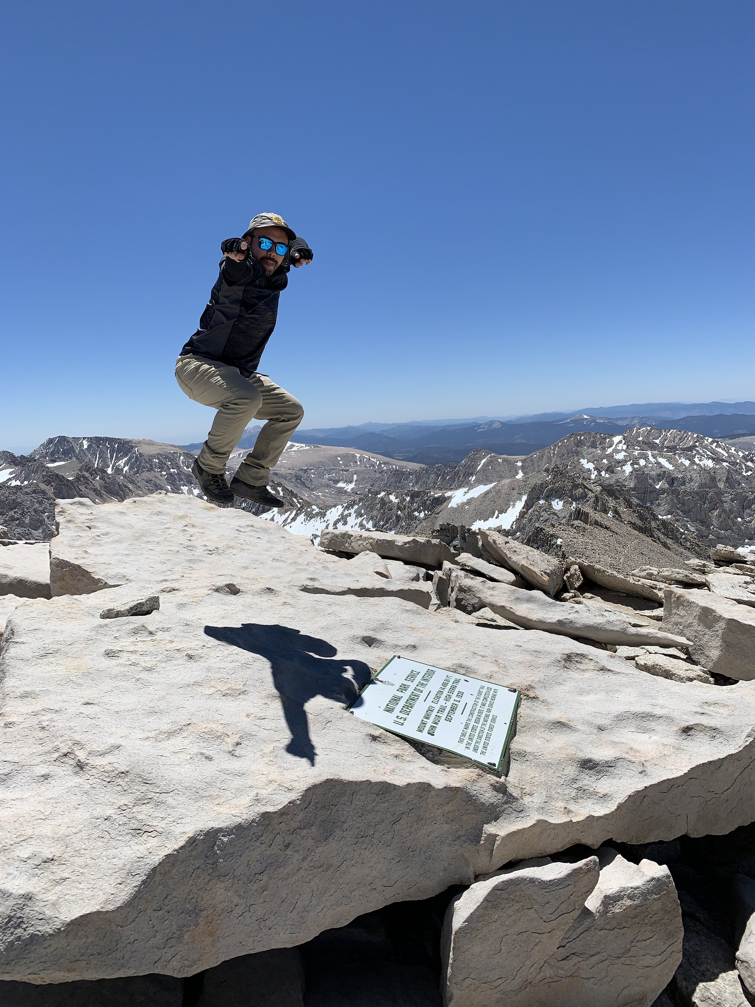
TRAIL CREST → MT. WHITNEY SUMMIT: This is the final level and this section is the highest trail pass in the United States at 13,500 ft elevation and is where alot of people start to feel more altitude sickness/AMS symptoms. If this is you, rest up and don’t force yourself up if you are feeling a pounding headache, bad nausea, vomiting, disorientation and so forth. In other words, don’t let “summit fever” get to you because you might terribly regret it later and the worst cases be something fatal. This section is EPIC and it looks like that scary mountain from Lord of the Rings called “Mordor.” The sharp dramatic, spires and the glacier carved lakes down below really give you a sense of accomplishment of just how far you have came on the journey and that the summit is within grasp for those who dare push on. Trail Crest goes through the backside of the mountain and then has you coming back around to the front. From here, it is 1.9 miles to the summit which doesn’t sound like much, but it definitely felt like the longest 1.9 miles that I have ever done because of the extreme altitude. Just take a slow and steady pace with many breaks. It was during this section that I realized I should have filled up on more water at Trail Camp/Consultation lake too. Let’s just say that the GU energy gels I had were lifesavers since I had lost my appetite for any kind of food and that I was running low on water. There is also a good amount of up and down on the beginning of this section that can tire you out, like I said before, just take your time. With about .5 miles, there was an area where you could do the long snow traverse up to the summit or you could rock scramble straight up. I decided to follow my friend up the rock scrambling route and it was so exhausting yet so much fun (I love rock scrambling). I would say in order to rock scramble this section that one must have strong legs because it will absolutely drain you if you are not prepared. So after scrambling for about 30 minutes or so, I finally saw a glimpse of the summit cabin. My eyes quickly lit up and I made the final push for the peak. As I was approaching the Mt. Whitney plaque, so many feelings were rushing through me and I felt like I was about to cry out of sheer happiness of making the summit. I touched the plaque and let out a huge sigh of relief and just soaked in my surroundings - I was on top of the tallest mountain in the contiguous United States. After about 15-20 minutes, I saw two other members of my group in the distance and cheered them on to make the final push. They were able to summit and couldn’t believe that we all had made it.
MT WHITNEY SUMMIT → TRAIL CAMP: We stayed at the summit for about 30-45 minutes. I had an unusual amount of energy for how exhausted I was - most likely all the adrenaline. I didn’t feel the effects of AMS since I had prepped so much but here at the summit I started to feel the beginning of a headache happen so I popped some advil to help alleviate it. One of our members had altitude sickness and felt very nauseated so we finally began our long descent back down - we had 11 miles to go back down the mountain in hopes of eating a juicy burger and fries at the Whitney Portal store. So this is when the day took an unfortunate twist. On our way down the 99 switchbacks part, one of the girls injured herself and dislocated her knee around the cables section. It was then I realized we had serious situation on our hands since we were still 6 miles from the trailhead. Not knowing whether we would have to somehow camp (we didn’t have camping gear since we were doing this as a day hike) or whether we would be able to receive help, my friend used her Garmin device (highly suggest having this if you are doing crazy mountains such as this) to contact search and rescue. We all somehow got to the base of the 99 switchbacks and rested. The girls even had to bust out their emergency blankets and bivy sacks as it started to become cold and daylight was starting to disappear. Since we were still a bit isolated from people, I knew we had to get our friend quickly to Trail camp since there would be a community of people who could possibly help us if we needed anything.
TRAIL CAMP → MT WHITNEY PORTAL: After waiting around 1.5 hours at the base of switchbacks, we helped our friend hobble over to the Trail Camp site where fellow campers shouted towards us to ask if we needed any help. All of a sudden a family came over (husband, wife, son and his gf) and basically adopted us and offered so much help - it was a beautiful thing. We finally got confirmation from Search and Rescue that they would be sending out an airship to our location but ONLY for the injured party and not us. At this point it was 7:15pm and we had lost so much daylight and time. The community of campers told us that they would wait with our friend until the helicopter came so that we could start hiking down the mountain. Equipped with our headlamps and only 1 hour of light left, we high tailed it down the mountain while enjoying the sights. We hiked in the dark for 3 hours and even picked up a fellow hiker who was just hiking by himself. We helped him out and somehow safely navigated the wilderness all the way to the Whitney Portal. I will say there were some really intense moments on the trek down that I will never forget. The hiker that we picked up on the way down at one point slipped on one of the rocks and did a 360 degree spin and fell down. I thought we were going to be stuck on the mountain because I thought this guy broke his leg or something. After about 10 seconds, he miraculously got up without injury. The other moment was literally under 1 mile from the the trailhead. The small stream that we had crossed in the early morning was now a thrashing mini river because of all the snow melting from the mountains tops the entire day. We all looked at each other with shock with how strong it looked and how loud it was. So with one last effort of adrenaline and precaution, we digged our trekking poles with much force into the ground while crossing the slippery rocks. We somehow made it across with no injury and all breathed a sign of relief. This mountain really would not stop testing us! It was an adventure for the books to say the least and am glad we made it back safe and sound. Hands down the most intense and surreal trek that I have ever done.